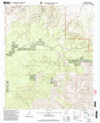
2001 Map of Queen
USGS Topo · Published 2003About this map
Sitting Bull Falls and the surrounding canyonlands of the Lincoln National Forest define this high-desert landscape at the turn of the 21st century. The settlement at Queen serves as a central point, supported by the Guadalupe Administrative Site and local landmarks like the Queen Cem and Guadalupe Church Camp. This area, which transitions into the northern reaches of Carlsbad Caverns National Park, is a study in arid-land water management, featuring a dense network of catchment systems such as Priestly Tank, Kite Windmill Storage Tank, and Watkins Tank. The rugged topography is etched with deep drainages including Dark Canyon and Last Chance Canyon, while the Guadalupe Ridge runs along the southern border, marking the boundary of the cavern park and the remote Putman Cabin.
Find a feature on this map
63 named features on this map. Tap any name to fly to it.
Don’t see what you’re looking for? This feature index may not catch every label — zoom into the map to look around manually.
Map Details
Editions of this 2001 Queen Map
This is the sole edition of this map. No revisions or reprints were ever made.
Other maps of this area

1935 · El Paso Gap
USGS Topo · 1:62,500

1936 · El Paso Gap
USGS Topo · 1:48,000

1940 · El Paso Gap
USGS Topo · 1:62,500

1940 · Bandanna Point
USGS Topo · 1:62,500

1940 · Carlsbad Caverns West
USGS Topo · 1:62,500

1943 · Carlsbad Caverns West
USGS Topo · 1:62,500

1943 · Bandanna Point
USGS Topo · 1:62,500

1943 · Texas Hill
USGS Topo · 1:62,500

1945 · Texas Hill
USGS Topo · 1:62,500

1954 · Carlsbad
USGS Topo · 1:250,000