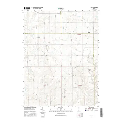
2016 Map of Quincy
USGS Topo · Published 2016About this map
Quincy serves as a central hub for this rural stretch where Putnam, Owen, and Morgan counties converge. The landscape is defined by the winding course of Mill Creek and the headwaters of Indian Creek, showing a pattern of small settlements and airfields spaced between family cemeteries. To the northwest, Wallace Junction indicates a significant point in the regional transport network, while smaller hamlets like Alaska and Lewisville anchor the eastern boundary. This area is dotted with small-scale aviation sites including Jack Oak Airport, Shearer Airport, and the Shenandoah Flying Field, reflecting a modern layer of land use alongside traditional rural markers like Combes Cemetery and Little Mount Cemetery. The topography transitions from the banks of Limestone Creek to the quiet waters of Lake Maxine, illustrating the drainage patterns that have historically influenced settlement in this part of Indiana.
Find a feature on this map
93 named features on this map. Tap any name to fly to it.
Don’t see what you’re looking for? This feature index may not catch every label — zoom into the map to look around manually.
Map Details
Editions of this 2016 Quincy Map
This is the sole edition of this map. No revisions or reprints were ever made.
Other maps of this area

1947 · Gosport
USGS Topo · 1:24,000

1949 · Quincy
USGS Topo · 1:24,000

1950 · Gosport
USGS Topo · 1:24,000

1953 · Indianapolis
USGS Topo · 1:250,000

1955 · Hall
USGS Topo · 1:24,000

1956 · Indianapolis
USGS Topo · 1:250,000

1956 · Cloverdale
USGS Topo · 1:24,000

1956 · Cataract
USGS Topo · 1:24,000

1956 · Eminence
USGS Topo · 1:24,000
1956 · Spencer
USGS Topo · 1:24,000