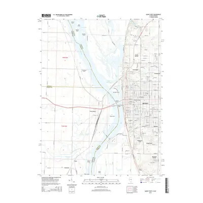
2015 Map of Quincy West
USGS Topo · Published 2015About this map
The Mississippi River defines the divide between Illinois and Missouri, creating a complex landscape of shifting channels and riverine islands. On the eastern shore, the city of Quincy dominates the bluffs, showing a dense street grid that incorporates the Quincy Univ campus and several significant local burial grounds such as Saint-Boniface Cem and Woodland Cem. The river's influence is clear through the numerous named landforms within the channel, including the large Quinsippi Island and Poage Island, separated by the Quincy Small Boat Channel. To the west, the Missouri side near West Quincy transitions into a more hydrologically active floodplain, where the Fabius River and Texas Chute carve through the bottomlands. This survey illustrates the intricate relationship between the urban development of Adams County and the natural drainage patterns of the Canton Chute and Durgens Creek.
Find a feature on this map
124 named features on this map. Tap any name to fly to it.
Don’t see what you’re looking for? This feature index may not catch every label — zoom into the map to look around manually.
Map Details
Editions of this 2015 Quincy West Map
This is the sole edition of this map. No revisions or reprints were ever made.
Other maps of this area

1903 · Kahoka
USGS Topo · 1:125,000

1903 · Palmyra
USGS Topo · 1:125,000

1925 · Quincy
USGS Topo · 1:62,500

1944 · Quincy
USGS Topo · 1:62,500

1945 · Quincy
USGS Topo · 1:62,500

1946 · Mendon
USGS Topo · 1:62,500

1948 · Quincy
USGS Topo · 1:250,000

1948 · Mendon
USGS Topo · 1:62,500

1949 · Maywood
USGS Topo · 1:24,000

1949 · Palmyra
USGS Topo · 1:24,000