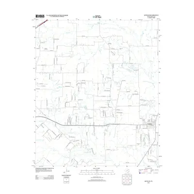
2012 Map of Quinlan
USGS Topo · Published 2012About this map
The S Fork Sabine River and its multiple tributaries, including Bearpen Cr and Jones Cr, define the southern reach of this Hunt County landscape. The settlement of Quinlan serves as the primary hub, situated at the junction of several state and county routes. The area is characterized by a high density of small water bodies and rural cemeteries that offer significant value for genealogical research, such as the Paynetown Cem and Hail Cem. To the northwest, Graham Point stands out as a distinct terrain feature and community anchor, accompanied by the Graham Point Cem. The drainage patterns of Caddo Cr and Dry Cr in the northeast illustrate the watershed's complexity before it reaches the larger river system to the south. This map documents a transition from the agricultural heritage of the Blackland Prairies toward more modern rural residential development.
Find a feature on this map
144 named features on this map. Tap any name to fly to it.
Don’t see what you’re looking for? This feature index may not catch every label — zoom into the map to look around manually.
Map Details
Editions of this 2012 Quinlan Map
This is the sole edition of this map. No revisions or reprints were ever made.
Other maps of this area

1919 · Royse City
USGS Topo · 1:62,500

1930 · Farmersville
USGS Topo · 1:62,500

1954 · Dallas
USGS Topo · 1:250,000

1954 · Sherman
USGS Topo · 1:250,000

1956 · Quinlan
USGS Topo · 1:62,500

1958 · Dallas
USGS Topo · 1:250,000

1958 · Sherman
USGS Topo · 1:250,000

1962 · Greenville SW
USGS Topo · 1:24,000

1962 · Greenville SE
USGS Topo · 1:24,000
1962 · Terrell North
USGS Topo · 1:24,000