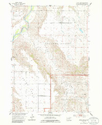
1954 Map of Quinn Table
USGS Topo · Published 1986About this map
The Cheyenne River winds through the northwest corner of this Pennington County landscape, where the flat alluvial plain of Brennan Flat transitions into the high, level plateau of Quinn Table. This 1954 field check captures the area's rural educational infrastructure with the Lincoln Sch and Quinn Table Sch serving as local landmarks in an era of dispersed ranching and dryland farming. To the south, the topography drops sharply into the eroded breaks and complex drainage networks of Badlands National Park. The map documents a water-dependent economy through features like Lakner Dam and a lone Windmill, while the network of ephemeral streams such as Sage Creek, Crooked Creek, and Anderson Draw illustrates the region's sharp relief and seasonal water patterns. Notable geological markers like White Butte stand as orienting points for surveyors and ranchers alike.
Find a feature on this map
21 named features on this map. Tap any name to fly to it.
Don’t see what you’re looking for? This feature index may not catch every label — zoom into the map to look around manually.
Map Details
Editions of this 1954 Quinn Table Map
2 editions found
Other maps of this area

1953 · Rapid City
USGS Topo · 1:250,000

1954 · Wasta SE
USGS Topo · 1:24,000

1954 · Scenic
USGS Topo · 1:24,000

1954 · Wasta
USGS Topo · 1:24,000

1954 · Owanka
USGS Topo · 1:24,000

1954 · Brennan Flat
USGS Topo · 1:24,000

1954 · Quinn Table
USGS Topo · 1:24,000

1955 · Hot Springs
USGS Topo · 1:250,000

1957 · Rapid City
USGS Topo · 1:250,000

1960 · Quinn Table NE
USGS Topo · 1:24,000