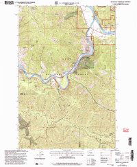
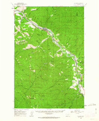
1999 Map of Quinns Hot Springs
USGS Topo · Published 2003About this map
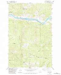
Quinns Hot Springs and the small settlement of Quinns sit at the dramatic confluence where the Flathead River joins the Clark Fork in western Montana. This 1999 revision reveals a landscape shaped by both recreation and resource extraction within the Lolo National Forest. Transportation corridors are critical here, with the John Tunnel marking a rail passage near the river, while high-elevation trails like the Old Pardee Trail and the Cascade Falls Nature Nat Rec Trail provide access to the steep drainage of Much Water Creek. Evidence of industrial history is found in the southern reaches, where the Hopkins Mine and various Prospect sites are marked near the Mineral and Missoula County line. From the heights of Patricks Knob Lookout down to the river banks, the map details a region where tourism at the springs meets a legacy of mountain mining.
Find a feature on this map
36 named features on this map. Tap any name to fly to it.
Don’t see what you’re looking for? This feature index may not catch every label — zoom into the map to look around manually.
Map Details
Editions of this 1999 Quinns Hot Springs Map
This is the sole edition of this map. No revisions or reprints were ever made.
Other maps of this area

1956 · Wallace
USGS Topo · 1:250,000
1959 · Tarkio
USGS Topo · 1:62,500
1959 · Perma
USGS Topo · 1:62,500
1959 · Plains
USGS Topo · 1:62,500

1960 · Wallace
USGS Topo · 1:250,000
1960 · Superior
USGS Topo · 1:62,500
1983 · Horsehead Peak
USGS Topo · 1:24,000
1984 · Paradise
USGS Topo · 1:24,000
1984 · Sunrise Spring
USGS Topo · 1:24,000
1984 · Knowles
USGS Topo · 1:24,000