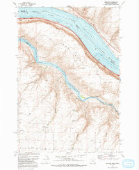
1971 Map of Quinton
USGS Topo · Published 1992About this map
Columbia River Lake Umatilla dominates the northern border of this landscape, where the waters of the Columbia and the John Day River Lake Umatilla meet at a massive hydraulic junction. The map illustrates a strictly industrial and agricultural environment, characterized by the Union Pacific and Burlington Northern railroads tracing the riverbanks and the presence of numerous Storage Bins for grain or equipment. Settlements like Quinton and Goodnoe appear as small hubs along the rail lines, serving the vast, dissected plateau above the river. The terrain is deeply incised by a network of drainage features including Biglow Canyon, Emigrant Canyon, and Draper Canyon, which fall away from the high ground of The Nook. Along the shoreline, Albert Philippi Park provides one of the few designated recreation areas in this river-and-rail corridor.
Find a feature on this map
24 named features on this map. Tap any name to fly to it.
Don’t see what you’re looking for? This feature index may not catch every label — zoom into the map to look around manually.
Map Details
Editions of this 1971 Quinton Map
2 editions found
Other maps of this area

1916 · Arlington
USGS Topo · 1:125,000

1953 · The Dalles
USGS Topo · 1:250,000

1956 · The Dalles
USGS Topo · 1:250,000

1957 · The Dalles
USGS Topo · 1:250,000

1957 · Wasco
USGS Topo · 1:62,500

1957 · Satus Pass
USGS Topo · 1:62,500

1964 · Mc Donald
USGS Topo · 1:24,000

1965 · Goodnoe Hills
USGS Topo · 1:24,000

1971 · Quinton
USGS Topo · 1:24,000
1971 · Sundale NW
USGS Topo · 1:24,000