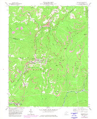
1972 Map of Quinwood
USGS Topo · Published 1982About this map
Quinwood and its neighboring coal-country settlements define this landscape during the early 1970s. The region is marked by an extensive industrial footprint, where Mines and Mine Dump sites are interspersed with small communities like Crichton, Leslie, and Marfrance. This map provides a detailed look at the resource-based economy of the Nicholas and Greenbrier county line, where the Chesapeake and Ohio and Conrail rail lines served as the primary conduits for local mineral wealth.
Find a feature on this map
66 named features on this map. Tap any name to fly to it.
Don’t see what you’re looking for? This feature index may not catch every label — zoom into the map to look around manually.
Map Details
Editions of this 1972 Quinwood Map
2 editions found
Other maps of this area

1887 · Hinton
USGS Topo · 1:125,000

1889 · Nicholas
USGS Topo · 1:125,000

1891 · Nicholas
USGS Topo · 1:125,000

1892 · Hinton
USGS Topo · 1:125,000

1901 · Nicholas
USGS Topo · 1:125,000

1912 · Meadow Creek
USGS Topo · 1:48,000

1914 · Winona
USGS Topo · 1:48,000

1915 · Meadow Creek
USGS Topo · 1:62,500

1916 · Winona
USGS Topo · 1:62,500

1918 · Richwood
USGS Topo · 1:62,500