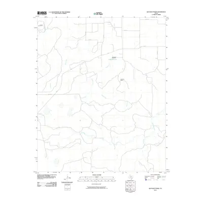
2010 Map of Quitaque Peaks
USGS Topo · Published 2010About this map
The Quitaque Railway Tunnel stands as a notable engineering landmark in the northwestern corner of this Motley County landscape, where the iron rail meets the caprock breaks. This 2010 survey illustrates a complex hydrological network defined by the North Pease River and several tributary drainages, including Brushy Creek, Hall Creek, and Roberts Creek. These waterways carve through the terrain surrounding the prominent Quitaque Peaks, a series of distinct topographic elevations that dominate the central part of the quadrangle.
Find a feature on this map
20 named features on this map. Tap any name to fly to it.
Don’t see what you’re looking for? This feature index may not catch every label — zoom into the map to look around manually.
Map Details
Editions of this 2010 Quitaque Peaks Map
This is the sole edition of this map. No revisions or reprints were ever made.
Other maps of this area

1954 · Plainview
USGS Topo · 1:250,000

1958 · Plainview
USGS Topo · 1:250,000

1966 · Lockney 4 SW
USGS Topo · 1:24,000

1967 · Quitaque
USGS Topo · 1:24,000

1967 · Quitaque Peaks
USGS Topo · 1:24,000

1967 · Dick Moore Canyon
USGS Topo · 1:24,000

1967 · Edgemon Lake
USGS Topo · 1:24,000

1967 · Flomot
USGS Topo · 1:24,000
1967 · Wilson Creek
USGS Topo · 1:24,000

1967 · Whiteflat
USGS Topo · 1:24,000