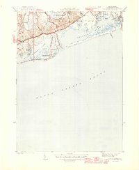
1944 Map of Quonochontaug
USGS Topo · Published 1944About this map
Ninigret Pond and Quonochontaug Pond dominate this coastal landscape, separated from the open Block Island Sound by the narrow, fragile barrier of East Beach and Quonochontaug Beach. Surveyed in 1942, the map documents a transitional era for the Rhode Island shore, where established settlements like Haversham and Shelter Harbor sit just inland from the marshes. To the north, the terrain shifts abruptly from the saltwater inlets to the protected woodlands of the Woody Hill Reservation and Burlingame Reservation. The mapping of the Saukatucket River and numerous small points such as Juniper Pt and Potato Pt reflects the intricate, tide-influenced geography of Charlestown. This 1944 edition captures the road network before major modern development, anchored by the Post Road and the coastal Shore Rd.
Find a feature on this map
33 named features on this map. Tap any name to fly to it.
Don’t see what you’re looking for? This feature index may not catch every label — zoom into the map to look around manually.
Map Details
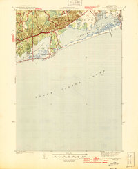
Editions of this 1944 Quonochontaug Map
2 editions found
Other maps of this area

1889 · Stonington
USGS Topo · 1:62,500

1889 · Charlestown
USGS Topo · 1:62,500

1889 · Block Island
USGS Topo · 1:62,500

1893 · Stonington
USGS Topo · 1:62,500

1894 · Block Island
USGS Topo · 1:62,500

1899 · Block Island
USGS Topo · 1:62,500

1904 · Montauk
USGS Topo · 1:62,500

1919 · Charlestown
USGS Topo · 1:62,500

1921 · Charlestown
USGS Topo · 1:62,500

1921 · Stonington
USGS Topo · 1:62,500