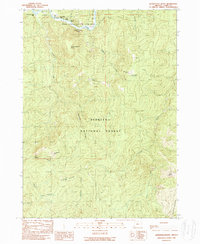
1989 Map of Quosatana Butte
USGS Topo · Published 1989About this map
The Rogue River dominates the northern landscape of this region, characterized by a series of named riffles and eddies including Quosatana Creek Riffle, Lowery Riffle, and Hayes Eddy. This 1989 survey captures a rugged river corridor designated as the Rogue National Wild and Scenic River, where recreational sites like Silver Creek Campground and a riverside Boat Ramp indicate the area's use for wilderness access. High points such as Quosatana Butte and Sugarloaf Mountain define the interior, which is largely managed as part of the Siskiyou National Forest.
Find a feature on this map
37 named features on this map. Tap any name to fly to it.
Don’t see what you’re looking for? This feature index may not catch every label — zoom into the map to look around manually.
Map Details
Editions of this 1989 Quosatana Butte Map
This is the sole edition of this map. No revisions or reprints were ever made.
Other maps of this area

1899 · Port Orford
USGS Topo · 1:125,000

1903 · Port Orford
USGS Topo · 1:125,000

1954 · Coos Bay
USGS Topo · 1:250,000

1954 · Port Orford
USGS Topo · 1:62,500

1954 · Gold Beach
USGS Topo · 1:62,500

1954 · Collier Butte
USGS Topo · 1:62,500

1954 · Agness
USGS Topo · 1:62,500

1958 · Coos Bay
USGS Topo · 1:250,000

1962 · Coos Bay
USGS Topo · 1:250,000
1986 · Sundown Mtn
USGS Topo · 1:24,000