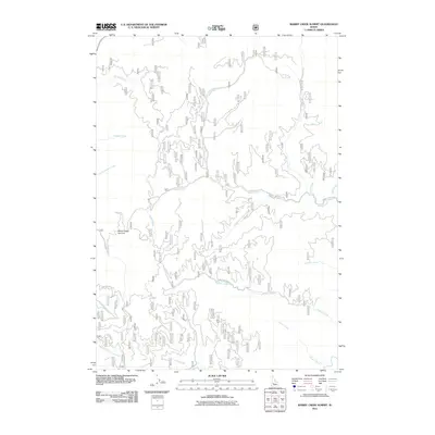
2011 Map of Rabbit Creek Summit
USGS Topo · Published 2011About this map
Rabbit Creek Summit serves as the focal high point for a drainage network in Elmore County, where mountain roads like Rabbit Creek Rd and Meadow Creek Rd provide the primary access to the backcountry. The map reveals an intricate hydrographic system defined by Rabbit Creek and its various tributaries, including the North Fork and South Fork. To the north and west, the landscape is carved by Hoodoo Creek and Boulder Creek, while the southern reaches are marked by the North Fork French Creek. This 2011 survey documents a wilderness area largely shaped by these waterways and the specialized forestry roads, such as Bannock Creek Rd and Thorn Butte Rd, which navigate the steep topography between the creek basins.
Find a feature on this map
23 named features on this map. Tap any name to fly to it.
Don’t see what you’re looking for? This feature index may not catch every label — zoom into the map to look around manually.
Map Details
Editions of this 2011 Rabbit Creek Summit Map
This is the sole edition of this map. No revisions or reprints were ever made.
Other maps of this area

1894 · Idaho Basin
USGS Topo · 1:125,000

1955 · Hailey
USGS Topo · 1:250,000

1957 · Pioneerville
USGS Topo · 1:24,000

1957 · Idaho City
USGS Topo · 1:24,000

1959 · Hailey
USGS Topo · 1:250,000

1962 · Hailey
USGS Topo · 1:250,000

1964 · Sheep Creek
USGS Topo · 1:24,000

1964 · Twin Springs
USGS Topo · 1:24,000
1969 · Arrowrock Reservoir NE
USGS Topo · 1:24,000
1972 · Rabbit Creek Summit
USGS Topo · 1:24,000