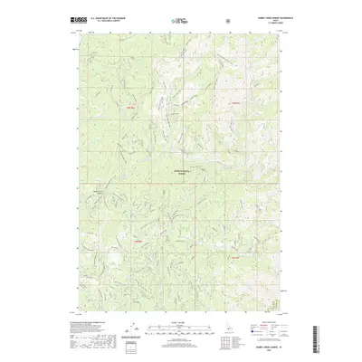
2020 Map of Rabbit Creek Summit
USGS Topo · Published 2020About this map
Boise National Forest dominates this landscape, where high-elevation ridgelines and steep drainages define the transition between Boise and Elmore counties. The topography is intricately mapped with forest service roads and specialized trails like the Rabbit Switchbacks and Rabbit Stew, indicating a region managed for both timber and recreation. Rabbit Creek Summit serves as a central landmark for this network of spurs and loops, including the Rabbit Creek Loop and Meadow Creek Cutoff.
Find a feature on this map
87 named features on this map. Tap any name to fly to it.
Don’t see what you’re looking for? This feature index may not catch every label — zoom into the map to look around manually.
Map Details
Editions of this 2020 Rabbit Creek Summit Map
This is the sole edition of this map. No revisions or reprints were ever made.
Other maps of this area

1894 · Idaho Basin
USGS Topo · 1:125,000

1955 · Hailey
USGS Topo · 1:250,000

1957 · Pioneerville
USGS Topo · 1:24,000

1957 · Idaho City
USGS Topo · 1:24,000

1959 · Hailey
USGS Topo · 1:250,000

1962 · Hailey
USGS Topo · 1:250,000

1964 · Sheep Creek
USGS Topo · 1:24,000

1964 · Twin Springs
USGS Topo · 1:24,000
1969 · Arrowrock Reservoir NE
USGS Topo · 1:24,000
1972 · Rabbit Creek Summit
USGS Topo · 1:24,000