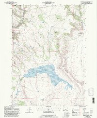
1992 Map of Rabbit Valley
USGS Topo · Published 1997About this map
The North Fork Crooked River carves through the high desert of Crook County, where the expansive Rabbit Valley and Paulina Valley are defined by an intricate network of livestock-related water improvements. Central to the landscape is the large Merwin Reservoir No 3, part of a chain that includes Merwin Reservoir No 2 and Merwin Reservoir No 1 to the southwest. This area, largely contained within the Ochogo Nat For, reveals the critical role of water management in a region dominated by volcanic landmarks like Pine Mtn and Isadore Butte. Historical land use is visible through features such as Scott Road, several sheep-related reservoirs, and a Pit near the Lakeside Ridge. The map identifies numerous natural springs, including Watson Spring and Luelling Spring, which likely served as vital watering holes for both wildlife and grazing livestock in this arid environment.
Find a feature on this map
43 named features on this map. Tap any name to fly to it.
Don’t see what you’re looking for? This feature index may not catch every label — zoom into the map to look around manually.
Map Details
Editions of this 1992 Rabbit Valley Map
This is the sole edition of this map. No revisions or reprints were ever made.
Other maps of this area

1932 · Dayville
USGS Topo · 1:125,000

1936 · Dayville
USGS Topo · 1:125,000

1955 · Bend
USGS Topo · 1:250,000

1955 · Canyon City
USGS Topo · 1:250,000

1957 · Bend
USGS Topo · 1:250,000

1958 · Bend
USGS Topo · 1:250,000

1959 · Canyon City
USGS Topo · 1:250,000

1965 · Williams Prairie
USGS Topo · 1:24,000

1966 · Keys Creek
USGS Topo · 1:24,000

1966 · Little Summit Prairie
USGS Topo · 1:24,000