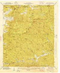
1947 Map of Rabun Bald
USGS Topo · Published 1947About this map
The Blue Ridge Divide winds through the heart of this 1946 field study, marking the rugged boundary between the Chattahoochee National Forest and Nantahala National Forest. Dominating the central landscape is Rabun Bald, crowned by a Lookout Tower that surveys a terrain defined by deep gaps and prominent knobs. To the northwest, the settlement of Dillard sits near the Tenn RR line, while the southern slopes descend toward Warwoman Dell and the waters of Warwoman Creek. This era of documentation highlights several family-named landmarks and essential rural infrastructure, including the Locust School and multiple isolated burying grounds like Kelly Cem and Duncan Cem. The map illustrates a mountain society deeply connected to its hydrology, with Estatoah Falls and numerous branches like Stillhouse Branch and Battle Branch carving through the granite ridges of the Georgia-North Carolina borderlands.
Find a feature on this map
116 named features on this map. Tap any name to fly to it.
Don’t see what you’re looking for? This feature index may not catch every label — zoom into the map to look around manually.
Map Details
Editions of this 1947 Rabun Bald Map
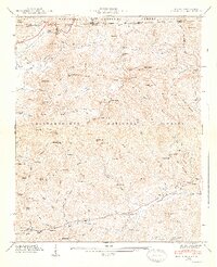
2 editions found
Other maps of this area

1886 · Walhalla
USGS Topo · 1:125,000

1891 · Cowee
USGS Topo · 1:125,000

1892 · Walhalla
USGS Topo · 1:125,000

1896 · Walhalla
USGS Topo · 1:125,000

1897 · Cowee
USGS Topo · 1:125,000

1907 · Cowee
USGS Topo · 1:125,000

1935 · Prentiss
USGS Topo · 1:24,000

1935 · Dillard
USGS Topo · 1:24,000

1935 · Scaly
USGS Topo · 1:24,000

1935 · Rabun Bald
USGS Topo · 1:24,000