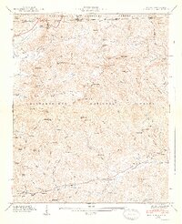
1947 Map of Rabun Bald
USGS Topo · Published 1947About this map
Rabun Bald towers over this section of the Blue Ridge, marking the high-elevation divide between the Nantahala National Forest in North Carolina and the Chattahoochee National Forest in Georgia. The landscape in the late 1940s is defined by a dense network of gaps and knobs, where settlements like Dillard and Mountain City are connected by the Tenn R R and early state routes. The map records the headwaters of the Warwoman Creek, where the Warwoman Dell recreational area sits near the small community of Antioch.
Find a feature on this map
100 named features on this map. Tap any name to fly to it.
Don’t see what you’re looking for? This feature index may not catch every label — zoom into the map to look around manually.
Map Details
Editions of this 1947 Rabun Bald Map
2 editions found
Other maps of this area

1886 · Walhalla
USGS Topo · 1:125,000

1891 · Cowee
USGS Topo · 1:125,000

1892 · Walhalla
USGS Topo · 1:125,000

1896 · Walhalla
USGS Topo · 1:125,000

1897 · Cowee
USGS Topo · 1:125,000

1907 · Cowee
USGS Topo · 1:125,000

1935 · Prentiss
USGS Topo · 1:24,000

1935 · Dillard
USGS Topo · 1:24,000

1935 · Scaly
USGS Topo · 1:24,000

1935 · Rabun Bald
USGS Topo · 1:24,000