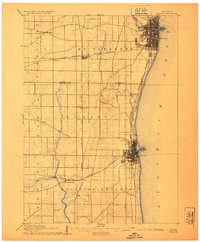
1905 Map of Racine
USGS Topo · Published 1923About this map
Racine and Kenosha anchor this turn-of-the-century coastal landscape, showing these industrial lakeside centers before the extensive urban sprawl of the later twentieth century. The map reveals a high concentration of rail infrastructure, with the Chicago Milwaukee and St. Paul Railroad and the Chicago and Northwestern Railroad forming a dense grid that powered the region's early manufacturing economy. Inland, the transition from urban hubs to agrarian townships like Yorkville and Bristol is immediate, marked by small junctions and rail-stop settlements such as Corliss and Sylvania.
Find a feature on this map
26 named features on this map. Tap any name to fly to it.
Don’t see what you’re looking for? This feature index may not catch every label — zoom into the map to look around manually.
Map Details
Editions of this 1905 Racine Map
3 editions found
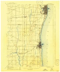
Other maps of this area

1891 · Bayview
USGS Topo · 1:62,500

1891 · Muskego
USGS Topo · 1:62,500

1892 · Racine
USGS Topo · 1:62,500

1893 · Silver Lake
USGS Topo · 1:62,500

1901 · Bayview
USGS Topo · 1:62,500

1901 · Muskego
USGS Topo · 1:62,500

1905 · Racine
USGS Topo · 1:62,500

1906 · Silver Lake
USGS Topo · 1:62,500

1906 · Waukegan
USGS Topo · 1:62,500

1908 · Waukegan
USGS Topo · 1:62,500