
1950 Map of Racine
USGS Topo · Published 1950About this map
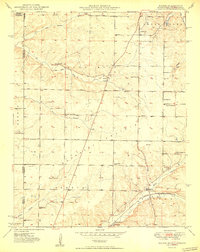
Tripoli Mines and smaller excavations dot the landscape south of Spring City, revealing the industrial character of this corner of Newton County at the midpoint of the twentieth century. The St Louis San Francisco railroad provides the primary transport artery, connecting the settlement at Racine to the broader regional economy. This era's rural social infrastructure is exceptionally well-documented, featuring a high density of country schools and churches, including Five Mile Sch, Willow Springs Sch, and New Hope Ch. The mapping also captures the tri-state boundary where Missouri meets Kansas and Oklahoma, marking the transition from the rolling hills near Five Mile Creek to the plains. Local family history is preserved through numerous small burial grounds like Buzzard Cem and Moser Cem, which remain as quiet landmarks along the township roads.
Find a feature on this map
41 named features on this map. Tap any name to fly to it.
Don’t see what you’re looking for? This feature index may not catch every label — zoom into the map to look around manually.
Map Details
Editions of this 1950 Racine Map
2 editions found
Other maps of this area

1886 · Joplin
USGS Topo · 1:125,000

1886 · Carthage
USGS Topo · 1:125,000

1894 · Joplin
USGS Topo · 1:125,000

1894 · Carthage
USGS Topo · 1:125,000

1907 · Wyandotte
USGS Topo · 1:125,000

1909 · Wyandotte
USGS Topo · 1:125,000

1916 · Neosho
USGS Topo · 1:62,500

1947 · Joplin
USGS Topo · 1:250,000

1949 · Joplin
USGS Topo · 1:250,000

1949 · Seneca
USGS Topo · 1:24,000