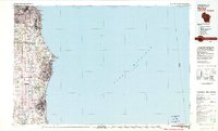
1980 Map of Racine
USGS Topo · Published 1981About this map
The industrialized shoreline of Lake Michigan anchors this 1980 survey, documenting the dense urban corridor stretching from Milwaukee south through Racine and Kenosha. The map captures a landscape defined by heavy transportation infrastructure and mid-century growth, featuring major aviation hubs like General Mitchell Field and the Kenosha Municipal Airport. Between these urban centers, smaller settlements like Kilbournville, Franksville, and Caledonia maintain their identities amidst a web of state highways and rail lines including the C & N W and C M St P & P. Educational and social institutions are prominent, with Dominican College and St Francis De Sales College appearing along the lakefront. The coastline itself is marked by the distinctive Wind Point and its Wind Point Lighthouse, while the interior is drained by the Root River and its various branches, illustrating the geographic relationship between the lakeside bluffs and the agricultural hinterlands of Milwaukee and Racine counties.
Find a feature on this map
79 named features on this map. Tap any name to fly to it.
Don’t see what you’re looking for? This feature index may not catch every label — zoom into the map to look around manually.
Map Details
Editions of this 1980 Racine Map
This is the sole edition of this map. No revisions or reprints were ever made.
Other maps of this area

1891 · Bayview
USGS Topo · 1:62,500

1891 · Muskego
USGS Topo · 1:62,500

1892 · Milwaukee
USGS Topo · 1:62,500

1892 · Waukesha
USGS Topo · 1:62,500

1892 · Racine
USGS Topo · 1:62,500

1893 · Silver Lake
USGS Topo · 1:62,500

1901 · Milwaukee
USGS Topo · 1:62,500

1901 · Waukesha
USGS Topo · 1:62,500

1901 · Bayview
USGS Topo · 1:62,500

1901 · Muskego
USGS Topo · 1:62,500