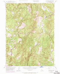
1948 Map of Rackerby
USGS Topo · Published 1971About this map
Brownsville and Rackerby anchor this landscape along the Butte and Yuba county line, reflecting a mid-century period of transition between early industrial logging and local ranching. The map reveals a network of homesteads and resource extraction sites, including the Central Pacific Mine and Robinson Mills, alongside small community centers like Frenchtown. Local educational history is preserved through the locations of the Sharon Valley Sch and Hansonville Sch, while the Graham Cem provides a specific point of interest for genealogists tracing early families in the region.
Find a feature on this map
49 named features on this map. Tap any name to fly to it.
Don’t see what you’re looking for? This feature index may not catch every label — zoom into the map to look around manually.
Map Details
Editions of this 1948 Rackerby Map
4 editions found
Other maps of this area

1888 · Smartsville
USGS Topo · 1:125,000

1888 · Bidwell Bar
USGS Topo · 1:125,000

1891 · Bidwell Bar
USGS Topo · 1:125,000

1891 · Smartsville
USGS Topo · 1:125,000

1892 · Smartsville
USGS Topo · 1:125,000

1893 · Bidwell Bar
USGS Topo · 1:125,000

1894 · Smartsville
USGS Topo · 1:125,000

1895 · Bidwell Bar
USGS Topo · 1:125,000

1895 · Smartsville
USGS Topo · 1:125,000

1897 · Bidwell Bar
USGS Topo · 1:125,000