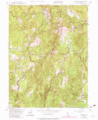
1948 Map of Rackerby
USGS Topo · Published 1982About this map
Rackerby and Brownsville anchor this 1940s landscape where the gold-bearing terrain of Butte and Yuba counties meets the Plumas National Forest. The map documents a working rural economy defined by small-scale mining and ranching, featuring the Central Pacific Mine, Three-in-One Mine, and Madrone Mine. Water management is central to the area's development, evidenced by the Wyandotte Canal winding through the foothills. Local genealogy and settlement history are well-preserved through labels for the Upham Cem, Sharon Valley Sch, and the Hansonville Sch. Numerous family-named homesteads and operations like Willow Glen Ranch, Finley Ranch, and Robinson Mills are scattered across the flats and ridges, including Swedes Flat and New York Flat, illustrating the early migration and land-use patterns of the Sierra Nevada foothills before mid-century modernization.
Find a feature on this map
44 named features on this map. Tap any name to fly to it.
Don’t see what you’re looking for? This feature index may not catch every label — zoom into the map to look around manually.
Map Details
Editions of this 1948 Rackerby Map
4 editions found
Other maps of this area

1888 · Smartsville
USGS Topo · 1:125,000

1888 · Bidwell Bar
USGS Topo · 1:125,000

1891 · Bidwell Bar
USGS Topo · 1:125,000

1891 · Smartsville
USGS Topo · 1:125,000

1892 · Smartsville
USGS Topo · 1:125,000

1893 · Bidwell Bar
USGS Topo · 1:125,000

1894 · Smartsville
USGS Topo · 1:125,000

1895 · Bidwell Bar
USGS Topo · 1:125,000

1895 · Smartsville
USGS Topo · 1:125,000

1897 · Bidwell Bar
USGS Topo · 1:125,000