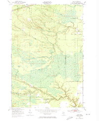
1951 Map of Raco
USGS Topo · Published 1974About this map
The Duluth South Shore and Atlantic railroad cuts across the northern edge of this Upper Peninsula landscape, serving the settlement of Raco and the nearby Raco Ranger Sta. This 1951 field survey captures a transition point in Michigan's timberlands, where the Marquette National Forest meets the Munuscong State Forest. The intricate drainage network of the West Branch Waiska River and White River reveals a low-lying, water-rich terrain defined by numerous small tributaries like Bons Creek and McMahon Creek.
Find a feature on this map
28 named features on this map. Tap any name to fly to it.
Don’t see what you’re looking for? This feature index may not catch every label — zoom into the map to look around manually.
Map Details
Editions of this 1951 Raco Map
3 editions found
Other maps of this area

1941 · Strongs
USGS Topo · 1:63,360

1941 · Brimley
USGS Topo · 1:63,360

1951 · Pendills Lake
USGS Topo · 1:24,000

1951 · Dollar Settlement
USGS Topo · 1:24,000

1951 · Sullivan Creek
USGS Topo · 1:24,000

1951 · Raco
USGS Topo · 1:24,000

1951 · Kinross
USGS Topo · 1:24,000

1951 · Brimley
USGS Topo · 1:62,500

1951 · Strongs
USGS Topo · 1:62,500

1951 · Brimley
USGS Topo · 1:24,000
Featured Places
- Trout Lake Township, MI
- Superior Township, MI
- Rudyard Township, MI
- Kinross Township, MI
- Chippewa County, MI