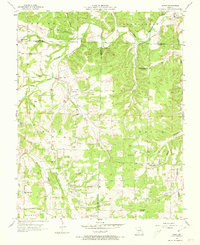
1956 Map of Rader
USGS Topo · Published 1973About this map
The Gasconade River and Osage Fork Gasconade River carve a winding course through this mid-1950s landscape where Laclede, Webster, and Wright counties meet. This rural area, centered on the small settlement of Rader, is defined by a dense network of country schools and churches that served the isolated valley communities. Many of these institutions, such as McMahan Sch and Amity Sch, reflect the local social structure before widespread district consolidation.
Find a feature on this map
32 named features on this map. Tap any name to fly to it.
Don’t see what you’re looking for? This feature index may not catch every label — zoom into the map to look around manually.
Map Details
Editions of this 1956 Rader Map
2 editions found
Other maps of this area

1939 · Long Lane
USGS Topo · 1:62,500

1941 · Lebanon
USGS Topo · 1:62,500

1942 · Long Lane
USGS Topo · 1:62,500

1943 · Lebanon
USGS Topo · 1:62,500

1946 · Niangua
USGS Topo · 1:62,500

1948 · Niangua
USGS Topo · 1:62,500

1954 · Springfield
USGS Topo · 1:250,000

1956 · Duncan
USGS Topo · 1:24,000

1956 · Rader
USGS Topo · 1:24,000
1956 · Hartville
USGS Topo · 1:24,000