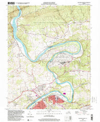
1998 Map of Radford North
USGS Topo · Published 2000About this map
The New River carves a dramatic, winding path through this portion of Montgomery and Pulaski Counties, defining the industrial and social development of Radford and its surroundings. The river’s sharp horseshoe bends enclose the massive Radford Army Ammunition Plant, a dominant feature that underscores the region's mid-century military manufacturing significance. To the north, the terrain rises into the Jefferson National Forest, where steep ridges like Brush Mountain and Cloyds Mtn overlook small rural settlements such as McCoy and Wake Forest.
Find a feature on this map
68 named features on this map. Tap any name to fly to it.
Don’t see what you’re looking for? This feature index may not catch every label — zoom into the map to look around manually.
Map Details
Editions of this 1998 Radford North Map
This is the sole edition of this map. No revisions or reprints were ever made.
Other maps of this area

1890 · Dublin
USGS Topo · 1:125,000

1890 · Christiansburg
USGS Topo · 1:125,000

1891 · Dublin
USGS Topo · 1:125,000

1923 · Pearisburg
USGS Topo · 1:62,500

1923 · Waiteville
USGS Topo · 1:62,500

1931 · Waiteville
USGS Topo · 1:48,000

1932 · Pearisburg
USGS Topo · 1:48,000

1932 · Blacksburg
USGS Topo · 1:48,000

1937 · Pearisburg
USGS Topo · 1:62,500

1937 · Blacksburg
USGS Topo · 1:62,500