
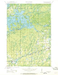
1944 Map of Radisson
USGS Topo · Published 1957About this map
The Chippewa River valley in Sawyer County defines this 1944 landscape, where the Chicago and North Western Railway follows the river's southern bank through the settlements of Radisson, Ojibwa, and Winter. Large portions of the northern terrain are managed as the Chequamegon National Forest and the Lac Court Oreilles Indian Reservation, including the community of New Post. The map reveals a highly connected water system featuring Scott Lake, Pokegama Lake, and Callahan Lake, alongside numerous small creeks like Blueberry Creek and Pipestone Creek. Local education and infrastructure are documented through features like Hunter Sch and the Pipestone Fire Tower, while Ojibwa State Park preserves the riverfront. This survey captures a moment when timber, rail, and early conservation efforts intersected in the Wisconsin Northwoods before significant mid-century changes.
Find a feature on this map
51 named features on this map. Tap any name to fly to it.
Don’t see what you’re looking for? This feature index may not catch every label — zoom into the map to look around manually.
Map Details
Editions of this 1944 Radisson Map
2 editions found
Other maps of this area

1942 · Clam Lake
USGS Topo · 1:48,000

1943 · Namekagon Lake
USGS Topo · 1:48,000

1944 · Exeland
USGS Topo · 1:48,000

1944 · Draper
USGS Topo · 1:48,000

1944 · Couderay
USGS Topo · 1:48,000

1944 · Hayward
USGS Topo · 1:48,000

1945 · Namekagon Lake
USGS Topo · 1:48,000

1945 · Clam Lake
USGS Topo · 1:48,000

1945 · Meteor
USGS Topo · 1:48,000

1945 · Ingram
USGS Topo · 1:48,000