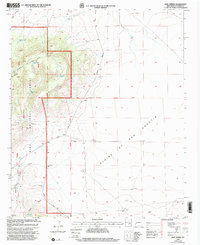
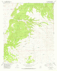
1999 Map of Rael Spring
USGS Topo · Published 2002About this map
The Tularosa Mountains rise abruptly from the Plains of San Agustin in this high-desert landscape of western New Mexico. Much of the western terrain is protected within the Gila National Forest, where the topography is defined by sharp drainages like Sawmill Canyon and Musick Canyon. The map reveals a land structured by water rights and ranching boundaries, dominated by the Triple T Ranch and a network of named water sources including Frank Well, Boss Well, and the eponymous Rael Spring. Human activity is concentrated along Bursum Road, which follows the transitional topography between the forest and the open plains. Large-scale surveying markers, including the Second Guide Meridian West and the First Standard Parallel South, illustrate how this expansive territory was organized into sections and townships.
Find a feature on this map
29 named features on this map. Tap any name to fly to it.
Don’t see what you’re looking for? This feature index may not catch every label — zoom into the map to look around manually.
Map Details
Editions of this 1999 Rael Spring Map
This is the sole edition of this map. No revisions or reprints were ever made.
Other maps of this area

1918 · Pelona
USGS Topo · 1:125,000

1954 · Clifton
USGS Topo · 1:250,000

1957 · Clifton
USGS Topo · 1:250,000

1958 · Clifton
USGS Topo · 1:250,000

1962 · Clifton
USGS Topo · 1:250,000

1981 · Fullerton
USGS Topo · 1:24,000
1981 · Bell Peak
USGS Topo · 1:24,000
1981 · Horse Mountain West
USGS Topo · 1:24,000
1981 · Collins Park
USGS Topo · 1:24,000
1981 · Rail Canyon
USGS Topo · 1:24,000