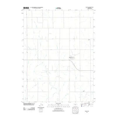
2011 Map of Ragan
USGS Topo · Published 2011About this map
Ragan serves as the primary hub of this rural Nebraska landscape, situated near the intersection of Division Ave and several arterial country roads. The community maintains a local focal point at the Ragan Post Office, reflecting its continued role as a service center for the surrounding agricultural community. The terrain is defined by the winding paths of Turkey Creek and Rope Creek, which drain the prairie landscape towards the south. Evidence of local land management and communal history appears in features like Hoffman Dam and Antelope Cemetery, the latter located in the northeast corner of the quadrangle. The map captures a strictly gridded road system, including routes like 725 Rd and T Rd, which carve the plains into regular sections typical of the region's development pattern.
Find a feature on this map
17 named features on this map. Tap any name to fly to it.
Don’t see what you’re looking for? This feature index may not catch every label — zoom into the map to look around manually.
Map Details
Editions of this 2011 Ragan Map
This is the sole edition of this map. No revisions or reprints were ever made.
Other maps of this area

1896 · Holdrege
USGS Topo · 1:125,000

1955 · Grand Island
USGS Topo · 1:250,000

1957 · Grand Island
USGS Topo · 1:250,000

1958 · Grand Island
USGS Topo · 1:250,000

1970 · Holdrege East
USGS Topo · 1:24,000

1970 · Axtell West
USGS Topo · 1:24,000

1970 · Wilcox
USGS Topo · 1:24,000

1970 · Ragan
USGS Topo · 1:24,000
1970 · Holdrege West
USGS Topo · 1:24,000
1970 · Atlanta
USGS Topo · 1:24,000