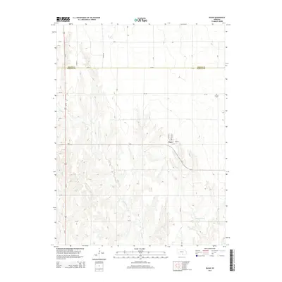
2014 Map of Ragan
USGS Topo · Published 2014About this map
Ragan sits at the intersection of Ne-4 and Decker Ave, serving as a central hub in this agricultural landscape near the border of Phelps Co and Harlan Co. The terrain is defined by the winding course of Turkey Cr, which carves through the undulating plains, creating a network of drainage patterns that stand in contrast to the rigid grid of the township's rural road system. This 2014 survey documents the enduring layout of the region's transport and water management, including the Hoffman Reservoir in the southeast. For those tracing local heritage, the inclusion of Antelope Cem northeast of the main town provides a specific point of interest for genealogical research within these prairie lands.
Find a feature on this map
26 named features on this map. Tap any name to fly to it.
Don’t see what you’re looking for? This feature index may not catch every label — zoom into the map to look around manually.
Map Details
Editions of this 2014 Ragan Map
This is the sole edition of this map. No revisions or reprints were ever made.
Other maps of this area

1896 · Holdrege
USGS Topo · 1:125,000

1955 · Grand Island
USGS Topo · 1:250,000

1957 · Grand Island
USGS Topo · 1:250,000

1958 · Grand Island
USGS Topo · 1:250,000

1970 · Holdrege East
USGS Topo · 1:24,000

1970 · Axtell West
USGS Topo · 1:24,000

1970 · Wilcox
USGS Topo · 1:24,000

1970 · Ragan
USGS Topo · 1:24,000
1970 · Holdrege West
USGS Topo · 1:24,000
1970 · Atlanta
USGS Topo · 1:24,000