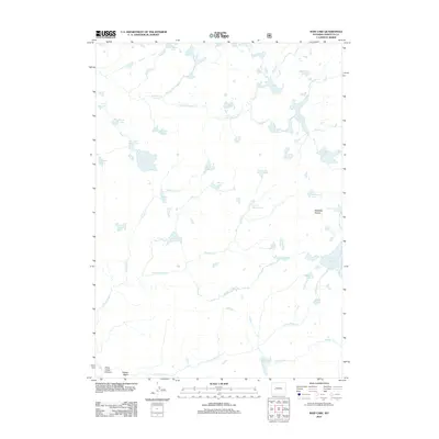
2012 Map of Raid Lake
USGS Topo · Published 2012About this map
Raid Lake serves as a central landmark in this high-altitude landscape within Sublette County, where an intricate network of alpine waters and glacial features defines the terrain. The topography is marked by distinctive formations such as Mitchells Nipple and the deep Silver Creek Canyon in the southwest. A complex drainage system connects Dream Lake, Crescent Lake, and Full Moon Lake through a series of creeks, including the S Fork Boulder Cr and Dream Cr. The map reveals a wild, unpopulated environment characterized by significant elevation changes, from the low-lying Willow Basin to the clustered Knob Lakes and Lightning Lakes. This 2012 survey captures the character of the Wyoming wilderness before modern developments, showing a landscape defined almost entirely by its natural water features and rugged granite peaks.
Find a feature on this map
43 named features on this map. Tap any name to fly to it.
Don’t see what you’re looking for? This feature index may not catch every label — zoom into the map to look around manually.
Map Details
Editions of this 2012 Raid Lake Map
This is the sole edition of this map. No revisions or reprints were ever made.
Other maps of this area

1938 · Mt Bonneville
USGS Topo · 1:62,500

1941 · Mt Bonneville
USGS Topo · 1:62,500

1942 · Mt Bonneville
USGS Topo · 1:62,500

1955 · Lander
USGS Topo · 1:250,000

1958 · Lander
USGS Topo · 1:250,000

1961 · Lander
USGS Topo · 1:250,000

1964 · Fremont Butte
USGS Topo · 1:24,000
1968 · Scab Creek
USGS Topo · 1:24,000
1968 · Horseshoe Lake
USGS Topo · 1:24,000

1969 · Pocket Creek Lake
USGS Topo · 1:24,000