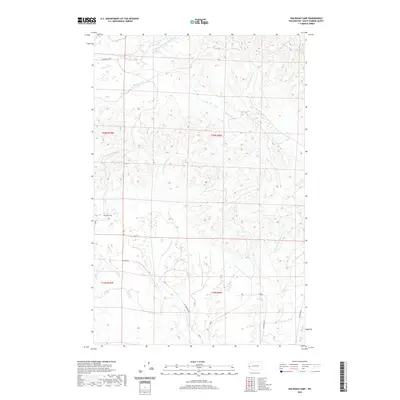
2020 Map of Railroad Camp
USGS Topo · Published 2020About this map
Railroad Camp serves as a focal point for this 2020 landscape in Grays Harbor County, where the intricate drainage systems of three major coastal rivers converge. The terrain is defined by the headwaters and tributaries of the East Fork Humptulips River, the E Fork Hoquiam River, and the Wishkah River. This high-elevation drainage divide is crisscrossed by essential forest and access roads, including E Humptulips Rd and W Wishkah Rd, which follow the natural contours of the ridges and valleys. Smaller waterways like Elwood Cr and Brittain Cr feed into the larger river systems, illustrating the complex hydrography of the Pacific Northwest timberlands. The presence of named drainages like S Br Big Cr and Ramey Cr highlights the detailed topographic record preserved in this modern survey of the region's industrial and natural geography.
Find a feature on this map
19 named features on this map. Tap any name to fly to it.
Don’t see what you’re looking for? This feature index may not catch every label — zoom into the map to look around manually.
Map Details
Editions of this 2020 Railroad Camp Map
This is the sole edition of this map. No revisions or reprints were ever made.
Other maps of this area

1921 · Quinault Lake
USGS Topo · 1:62,500

1921 · Satsop
USGS Topo · 1:62,500

1941 · Mobray
USGS Topo · 1:62,500

1943 · Humptulips
USGS Topo · 1:62,500

1943 · Mobray
USGS Topo · 1:62,500

1955 · Wynoochee Valley
USGS Topo · 1:62,500

1955 · Grisdale
USGS Topo · 1:62,500

1955 · Humptulips
USGS Topo · 1:62,500

1955 · Quinault Lake
USGS Topo · 1:62,500

1958 · Seattle
USGS Topo · 1:250,000