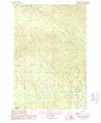
1990 Map of Railroad Camp
USGS Topo · Published 1990About this map
Railroad Camp (Site) sits at the heart of this landscape, reflecting a time when the timber industry and rail lines dictated the geography of Grays Harbor County. An extensive Old Railroad Grade winds through the hills, marking the path of former logging infrastructure that once connected these forests to the mills. This 1990 provisional map records the transitional state of the region, where industrial activity met large-scale conservation efforts like the Olympic State Wildlife Area.
Find a feature on this map
17 named features on this map. Tap any name to fly to it.
Don’t see what you’re looking for? This feature index may not catch every label — zoom into the map to look around manually.
Map Details
Editions of this 1990 Railroad Camp Map
This is the sole edition of this map. No revisions or reprints were ever made.
Other maps of this area

1921 · Quinault Lake
USGS Topo · 1:62,500

1921 · Satsop
USGS Topo · 1:62,500

1941 · Mobray
USGS Topo · 1:62,500

1943 · Humptulips
USGS Topo · 1:62,500

1943 · Mobray
USGS Topo · 1:62,500

1955 · Wynoochee Valley
USGS Topo · 1:62,500

1955 · Grisdale
USGS Topo · 1:62,500

1955 · Humptulips
USGS Topo · 1:62,500

1955 · Quinault Lake
USGS Topo · 1:62,500

1958 · Seattle
USGS Topo · 1:250,000