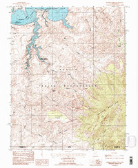
1987 Map of Rainbow Bridge
USGS Topo · Published 1987About this map
Rainbow Bridge National Monument stands as the centerpiece of this desert terrain, where the world's largest natural bridge spans Bridge Canyon. To the north, the waters of Lake Powell fill the winding canyons of the Colorado River within the Glen Canyon National Recreation Area. The landscape is defined by the massive uplift of Navajo Mountain to the southeast and the deeply incised drainage systems of the Navajo Indian Reservation. This survey documents the complex topography of the late twentieth century, including landmarks like Owl Bridge and Dougi Butte. The map illustrates the convergence of multiple canyon systems, such as Cliff Canyon and Forbidding Canyon, which navigate the sandstone formations and provide the only passable routes through this labyrinthine section of San Juan County.
Find a feature on this map
32 named features on this map. Tap any name to fly to it.
Don’t see what you’re looking for? This feature index may not catch every label — zoom into the map to look around manually.
Map Details
Editions of this 1987 Rainbow Bridge Map
2 editions found
Other maps of this area

1883 · Marsh Pass
USGS Topo · 1:250,000

1886 · Escalante
USGS Topo · 1:250,000

1886 · Henry Mountains
USGS Topo · 1:250,000

1886 · Echo Cliffs
USGS Topo · 1:250,000

1891 · Echo Cliffs
USGS Topo · 1:250,000

1892 · Marsh Pass
USGS Topo · 1:250,000

1892 · Henry Mountains
USGS Topo · 1:250,000

1953 · Cummings Mesa
USGS Topo · 1:62,500

1953 · Navajo Mountain
USGS Topo · 1:62,500

1954 · Navajo Creek
USGS Topo · 1:62,500