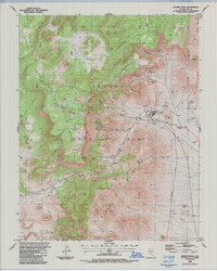
1986 Map of Rainier Mesa
USGS Topo · Published 1987About this map
Nevada Test Site operations define this high-desert landscape in the mid-1980s, revealing a complex industrial and scientific infrastructure within the Eleana Range. The map documents a dense concentration of Drill Holes across the plateau of Rainier Mesa, alongside facilities like the Area 12 Camp, a Heliport, and a Radio Facility. This specialized land use is superimposed over a dramatic natural topography featuring Kawich Canyon and Gold Meadows. To the east, the terrain drops toward Whiterock Spring and a series of Borrow Pits, while natural landmarks like Egg Point and Pinyon Butte anchor the southern reaches. The presence of numerous Adits, an Aqueduct, and specialized Adit Vents underscores the intensive underground activities that shaped this unique administrative territory.
Find a feature on this map
33 named features on this map. Tap any name to fly to it.
Don’t see what you’re looking for? This feature index may not catch every label — zoom into the map to look around manually.
Map Details
Editions of this 1986 Rainier Mesa Map
This is the sole edition of this map. No revisions or reprints were ever made.
Other maps of this area

1908 · Kawich
USGS Topo · 1:250,000

1942 · Wheelbarrow Peak
USGS Topo · 1:125,000

1952 · Tippipah Spring
USGS Topo · 1:62,500

1952 · Timber Mountain
USGS Topo · 1:62,500

1952 · Wheelbarrow Peak
USGS Topo · 1:62,500

1952 · Silent Canyon
USGS Topo · 1:62,500

1954 · Goldfield
USGS Topo · 1:250,000

1955 · Goldfield
USGS Topo · 1:250,000

1958 · Goldfield
USGS Topo · 1:250,000
1960 · Yucca Flat
USGS Topo · 1:24,000