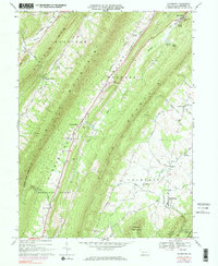
1967 Map of Rainsburg
USGS Topo · Published 1984About this map
The Cumberland Valley and Bedford Valley corridors define this mid-century landscape, where the ridges of Harrison Mountain and Evitts Mountain hem in long-established mountain settlements. Near the northern edge, the renowned mineral waters at Bedford Springs are highlighted by labels for Magnesium Spring and Crystal Spring, reflecting the area's legacy as a 19th-century resort destination. Further south, the borough of Rainsburg sits at a junction of rural routes, surrounded by family-centered landmarks like Yeager Ch and Beegleton. The presence of the Penn Central line and several named gravel pits suggests a local economy tied to the land and transport, while labels like Burning Bush and the County Home provide specific points of interest for genealogists tracing local history in these valley gaps.
Find a feature on this map
48 named features on this map. Tap any name to fly to it.
Don’t see what you’re looking for? This feature index may not catch every label — zoom into the map to look around manually.
Map Details
Editions of this 1967 Rainsburg Map
4 editions found
Other maps of this area

1900 · Everett
USGS Topo · 1:62,500

1902 · Everett
USGS Topo · 1:62,500

1908 · Bedford
USGS Topo · 1:62,500

1910 · Bedford
USGS Topo · 1:62,500

1927 · Clearville
USGS Topo · 1:48,000

1927 · Hyndman
USGS Topo · 1:62,500

1931 · Clearville
USGS Topo · 1:62,500

1931 · Hyndman
USGS Topo · 1:62,500

1944 · Hyndman
USGS Topo · 1:62,500

1944 · Clearville
USGS Topo · 1:62,500
Featured Places
- Rainsburg, PA
- Colerain Township, PA
- Bedford Township, PA
- Cumberland Valley Township, PA
- Harrison Township, PA