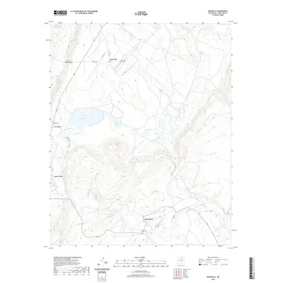
2020 Map of Rainsville
USGS Topo · Published 2020About this map
Rainsville and the surrounding high-altitude basin of Mora County are defined by a complex network of traditional water management and small agricultural settlements. The landscape is marked by the presence of numerous small lakes including Red Lake, Horse Lake, and Shufeldt Lake, which dot the terrain alongside man-made irrigation features like the Buena Vista Ditch and N Golondrinas Ditch. These ditches reflect the historic and continuing importance of water rights in this semi-arid region, feeding from the Mora River and Coyote Cr to support the local homesteads. For genealogists and local historians, the map provides precise locations for several community burial grounds, such as Sacred Heart Church Cem near Rainsville and the Jager Cem and Golondrinas Cem further south. The convergence of State RD 442 and local routes like La Lomita RD highlights the enduring footprint of these rural communities nestled between mountain passes like the Puerto del Venado Alazán.
Find a feature on this map
32 named features on this map. Tap any name to fly to it.
Don’t see what you’re looking for? This feature index may not catch every label — zoom into the map to look around manually.
Map Details
Editions of this 2020 Rainsville Map
This is the sole edition of this map. No revisions or reprints were ever made.
Other maps of this area

1889 · Las Vegas
USGS Topo · 1:125,000

1891 · Las Vegas
USGS Topo · 1:125,000

1893 · Las Vegas
USGS Topo · 1:125,000

1954 · Santa Fe
USGS Topo · 1:250,000

1954 · Raton
USGS Topo · 1:250,000

1958 · Raton
USGS Topo · 1:250,000

1958 · Santa Fe
USGS Topo · 1:250,000

1963 · Lake Isabel
USGS Topo · 1:24,000

1963 · Fort Union
USGS Topo · 1:24,000

1963 · Rainsville
USGS Topo · 1:24,000