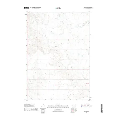
2017 Map of Rainy Creek
USGS Topo · Published 2017About this map
N Fork Rainy Cr and S Fork Rainy Cr converge in this high-plains landscape of western South Dakota, forming the headwaters of Rainy Creek. The terrain is defined by a dendritic drainage pattern where Cow Creek, Bull Creek, and Deep Creek carve through the open range. This 2017 survey illustrates a sparse ranching and agricultural network organized by the Public Land Survey System, with section lines marked by a grid of rural routes. Prominent thoroughfares like Wall Pedro Road, Creighton Road, and Geigle Road provide the primary connectivity across these vast townships. The map documents the persistent rural character of Pennington County, where the infrastructure is limited to the essential section-line roads and the seasonal flow of the creeks that sustain the local landscape.
Find a feature on this map
23 named features on this map. Tap any name to fly to it.
Don’t see what you’re looking for? This feature index may not catch every label — zoom into the map to look around manually.
Map Details
Editions of this 2017 Rainy Creek Map
This is the sole edition of this map. No revisions or reprints were ever made.
Other maps of this area

1953 · Rapid City
USGS Topo · 1:250,000

1954 · Dalzell SE
USGS Topo · 1:24,000

1954 · Wasta NE
USGS Topo · 1:24,000

1954 · Wasta SE
USGS Topo · 1:24,000

1955 · Creighton
USGS Topo · 1:24,000

1955 · Pedro SE
USGS Topo · 1:24,000

1957 · Rapid City
USGS Topo · 1:250,000
1983 · Horse Tooth
USGS Topo · 1:24,000
1983 · Elm Creek Ranch
USGS Topo · 1:24,000
1983 · Lake Hill
USGS Topo · 1:24,000