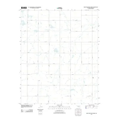
2012 Map of Rainy Mountain Creek
USGS Topo · Published 2012About this map
Rainy Mountain Cr defines the drainage of this Kiowa County landscape, where a series of flood-control reservoirs dominate the rural geography. The hydrology of the area was heavily managed by the early 21st century, with specifically numbered sites like Rainy Mountain Cr Site 25 Reservoir and Rainy Mountain Cr Site 15-B Reservoir intercepting the creek's flow across the plains. These engineered water bodies are situated within a strict grid of section-line roads, such as n2270 RD and e1410 RD, which reflect the region's agricultural layout. Rising above the flat agricultural lands in the southeast corner is the isolated profile of Blue Mtn, providing a distinct topographical contrast to the surrounding reservoir-dotted plains.
Find a feature on this map
25 named features on this map. Tap any name to fly to it.
Don’t see what you’re looking for? This feature index may not catch every label — zoom into the map to look around manually.
Map Details
Editions of this 2012 Rainy Mountain Creek Map
This is the sole edition of this map. No revisions or reprints were ever made.
Other maps of this area

1949 · Cooperton
USGS Topo · 1:62,500

1955 · Lawton
USGS Topo · 1:250,000

1955 · Clinton
USGS Topo · 1:250,000

1956 · Glen Mountains
USGS Topo · 1:24,000

1956 · Cooperton
USGS Topo · 1:24,000

1956 · Unap Mountain
USGS Topo · 1:24,000

1956 · Rainy Mountain Creek
USGS Topo · 1:24,000

1956 · Cooperton
USGS Topo · 1:62,500

1957 · Clinton
USGS Topo · 1:250,000

1961 · Gotebo
USGS Topo · 1:62,500