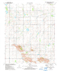
1991 Map of Rainy Mountain Creek
USGS Topo · Published 1992About this map
Rainy Mountain Creek winds across this Kiowa County landscape, defining a region where the natural terrain and petroleum extraction meet. In this 1980s-era survey, the southern portion is dominated by the prominent rise of Blue Mountain, while the surrounding plains are dotted with numerous Oil Well sites and a network of pipelines. These features reflect the industrial character of the Oklahoma countryside during this period, showing a pattern of energy development interwoven with the local geography. Significant markers such as a Gravel Pit and a lone Drill Hole provide specific points of interest for those studying the physical and economic history of the area. This map, compiled from 1987 aerial photography, captures the precise distribution of infrastructure and natural drainage as it existed before the turn of the century.
Find a feature on this map
7 named features on this map. Tap any name to fly to it.
Don’t see what you’re looking for? This feature index may not catch every label — zoom into the map to look around manually.
Map Details
Editions of this 1991 Rainy Mountain Creek Map
This is the sole edition of this map. No revisions or reprints were ever made.
Other maps of this area

1949 · Cooperton
USGS Topo · 1:62,500

1955 · Lawton
USGS Topo · 1:250,000

1955 · Clinton
USGS Topo · 1:250,000

1956 · Glen Mountains
USGS Topo · 1:24,000

1956 · Cooperton
USGS Topo · 1:24,000

1956 · Unap Mountain
USGS Topo · 1:24,000

1956 · Rainy Mountain Creek
USGS Topo · 1:24,000

1956 · Cooperton
USGS Topo · 1:62,500

1957 · Clinton
USGS Topo · 1:250,000

1961 · Gotebo
USGS Topo · 1:62,500