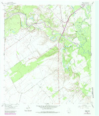
1962 Map of Raisin
USGS Topo · Published 1987About this map
Coleto Creek meanders through this landscape, joining the Guadalupe River amidst a complex network of oxbows and bottomlands including McDonald Lake, Adler Lake, and Shell and Trigger Lake. In the northwest, the settlement of Raisin sits along the Southern Pacific railroad line, while the southern reaches feature the Kemper City Sch and the expansive Terrell Ranch. The interplay between the river system and early land use is evident in the concentration of family landmarks like the McDonald Cem and the Reeves Cem. Further inland, the presence of an Indian Mound near Samson Bayou and the Stubbs Sch reflect a long history of occupation near these critical water sources. The map also documents the mid-century industrial footprint with numerous gas wells and an Oil Field established north of the creek.
Find a feature on this map
45 named features on this map. Tap any name to fly to it.
Don’t see what you’re looking for? This feature index may not catch every label — zoom into the map to look around manually.
Map Details
Editions of this 1962 Raisin Map
Other maps of this area

1951 · Bloomington
USGS Topo · 1:24,000

1952 · Bloomington SW
USGS Topo · 1:24,000

1952 · Victoria East
USGS Topo · 1:24,000

1953 · Beeville
USGS Topo · 1:250,000

1956 · Beeville
USGS Topo · 1:250,000

1960 · Beeville
USGS Topo · 1:250,000

1962 · Fannin
USGS Topo · 1:24,000

1962 · Lott Lake
USGS Topo · 1:24,000

1962 · McFaddin
USGS Topo · 1:24,000

1962 · Raisin
USGS Topo · 1:24,000