
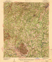
1943 Map of Raleigh
USGS Topo · Published 1943About this map
Raleigh centers this 1940s landscape as the hub of a thriving regional network defined by the Neuse River and a trio of major rail lines including the Seaboard Railway and Norfolk Southern RR. The capital city is surrounded by an array of educational and social institutions, from the campus of Meredith College and State College to the State Hospital and County Home. Smaller communities like the historically significant Method and the milling site at Milburnie sit just outside the urban core.
Find a feature on this map
90 named features on this map. Tap any name to fly to it.
Don’t see what you’re looking for? This feature index may not catch every label — zoom into the map to look around manually.
Map Details
Editions of this 1943 Raleigh Map
2 editions found
Other maps of this area

1943 · Durham South
USGS Topo · 1:62,500

1943 · Creedmoor
USGS Topo · 1:62,500

1944 · Creedmoor
USGS Topo · 1:62,500

1951 · Raleigh
USGS Topo · 1:62,500

1951 · Durham South
USGS Topo · 1:62,500

1951 · Durham North
USGS Topo · 1:62,500

1953 · Raleigh
USGS Topo · 1:250,000

1953 · Greensboro
USGS Topo · 1:250,000

1954 · Greensboro
USGS Topo · 1:250,000

1954 · Raleigh
USGS Topo · 1:250,000