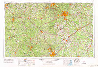
1953 Map of Raleigh
USGS Topo · Published 1971About this map
The Fort Bragg Military Reservation dominates the southern landscape of this mid-century survey, anchoring a region defined by its major river systems and burgeoning academic centers. From the University of North Carolina at Chapel Hill to North Carolina State University in Raleigh, the map illustrates the connectivity of the Research Triangle before the full expansion of the modern interstate system.
Find a feature on this map
66 named features on this map. Tap any name to fly to it.
Don’t see what you’re looking for? This feature index may not catch every label — zoom into the map to look around manually.
Map Details
Editions of this 1953 Raleigh Map
4 editions found

Other maps of this area

1902 · Kenly
USGS Topo · 1:62,500

1902 · Rocky Mount
USGS Topo · 1:62,500

1902 · Spring Hope
USGS Topo · 1:62,500

1903 · Kenly
USGS Topo · 1:62,500

1904 · Rocky Mount
USGS Topo · 1:62,500

1904 · Springhope
USGS Topo · 1:62,500

1904 · Wilson
USGS Topo · 1:62,500

1906 · Four Oaks
USGS Topo · 1:48,000

1908 · Four Oaks
USGS Topo · 1:62,500

1909 · Coharie
USGS Topo · 1:62,500