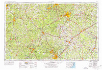
1953 Map of Raleigh
USGS Topo · Published 1976About this map
The capital city of Raleigh anchors this mid-century portrait of North Carolina's Piedmont and sandhills, appearing alongside the established academic and industrial hubs of Durham and Chapel Hill. The landscape is defined by its drainage basins, with the Neuse River and Cape Fear River systems carved into the terrain. In the southwest, the Uwharrie Mountains and the Uwharrie National Forest provide a contrast to the dense network of small towns like Siler City and Ramseur that grew around the region's textile and furniture heritage.
Find a feature on this map
98 named features on this map. Tap any name to fly to it.
Don’t see what you’re looking for? This feature index may not catch every label — zoom into the map to look around manually.
Map Details
Editions of this 1953 Raleigh Map
4 editions found

Other maps of this area

1902 · Kenly
USGS Topo · 1:62,500

1902 · Rocky Mount
USGS Topo · 1:62,500

1902 · Spring Hope
USGS Topo · 1:62,500

1903 · Kenly
USGS Topo · 1:62,500

1904 · Rocky Mount
USGS Topo · 1:62,500

1904 · Springhope
USGS Topo · 1:62,500

1904 · Wilson
USGS Topo · 1:62,500

1906 · Four Oaks
USGS Topo · 1:48,000

1908 · Four Oaks
USGS Topo · 1:62,500

1909 · Coharie
USGS Topo · 1:62,500