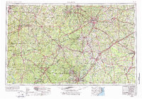
1953 Map of Raleigh
USGS Topo · Published 1976About this map
The Fort Bragg Military Reservation dominates the southern landscape of this mid-century survey, a massive installation flanked by Pope AFB and Mackall AAF. The region is defined by the transition from the Piedmont to the Sandhills, with the Uwharrie National Forest anchoring the western edge. This map reveals a complex network of small manufacturing and textile towns like Cedar Falls, Randleman, and Ramseur along the Deep River. Significant cultural landmarks include the Town Creek Indian Mound and the Bentonville Battlefield, preserving layers of indigenous and Civil War history. The convergence of the Southern RR and Seaboard Coast Line RR illustrates the area's industrial connectivity, serving as a vital corridor for the furniture and textile centers of High Point and Asheboro during a period of significant regional growth.
Find a feature on this map
172 named features on this map. Tap any name to fly to it.
Don’t see what you’re looking for? This feature index may not catch every label — zoom into the map to look around manually.
Map Details
Editions of this 1953 Raleigh Map
4 editions found

Other maps of this area

1902 · Kenly
USGS Topo · 1:62,500

1902 · Rocky Mount
USGS Topo · 1:62,500

1902 · Spring Hope
USGS Topo · 1:62,500

1903 · Kenly
USGS Topo · 1:62,500

1904 · Rocky Mount
USGS Topo · 1:62,500

1904 · Springhope
USGS Topo · 1:62,500

1904 · Wilson
USGS Topo · 1:62,500

1906 · Four Oaks
USGS Topo · 1:48,000

1908 · Four Oaks
USGS Topo · 1:62,500

1909 · Coharie
USGS Topo · 1:62,500