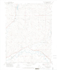
1971 Map of Ralph White Lake
USGS Topo · Published 1974About this map
Yampa River bottomlands and the winding path of the Denver and Rio Grande Western railroad dominate the southern reaches of this Northwest Colorado landscape. The 1971 terrain reveals a complex network of agricultural water management, including the Wisconsin Ditch, Norvell Ditch, and Deep Cut Ditch, which redirect water across the arid high-desert draws. Settlement is sparse, represented by landmarks like Dowden Bridge on Fortification Creek.
Find a feature on this map
26 named features on this map. Tap any name to fly to it.
Don’t see what you’re looking for? This feature index may not catch every label — zoom into the map to look around manually.
Map Details
Editions of this 1971 Ralph White Lake Map
This is the sole edition of this map. No revisions or reprints were ever made.
Other maps of this area

1910 · Danforth Hills
USGS Topo · 1:125,000

1915 · Monument Butte
USGS Topo · 1:62,500

1916 · Craig
USGS Topo · 1:125,000

1916 · Daton Peak
USGS Topo · 1:62,500

1920 · Daton Peak
USGS Topo · 1:62,500

1923 · Elkhead Creek
USGS Topo · 1:62,500

1924 · Elkhead Creek
USGS Topo · 1:62,500

1954 · Craig
USGS Topo · 1:250,000

1957 · Craig
USGS Topo · 1:250,000

1958 · Craig
USGS Topo · 1:250,000