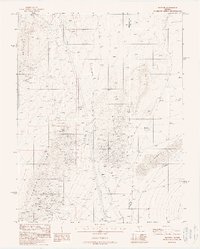
1988 Map of Ralston
USGS Topo · Published 1988About this map
Cuprite Hills and the Gold Field Hills dominate this high-desert landscape in Esmeralda County, showing a region defined by its extractive history and transit corridors. The map records a proliferation of Mine Shafts and prospects concentrated in the western heights, reflecting the intensive mineral exploration that shaped this part of Nevada. At the base of these hills lies Cuprite, while to the east, the broad expanse of Stonewall Flat opens up toward the Esmeralda and Nye County line.
Find a feature on this map
13 named features on this map. Tap any name to fly to it.
Don’t see what you’re looking for? This feature index may not catch every label — zoom into the map to look around manually.
Map Details
Editions of this 1988 Ralston Map
This is the sole edition of this map. No revisions or reprints were ever made.
Other maps of this area

1908 · Lida
USGS Topo · 1:250,000

1913 · Lida
USGS Topo · 1:250,000

1945 · Goldfield
USGS Topo · 1:125,000

1952 · Goldfield
USGS Topo · 1:62,500

1954 · Goldfield
USGS Topo · 1:250,000

1955 · Goldfield
USGS Topo · 1:250,000

1958 · Goldfield
USGS Topo · 1:250,000

1962 · Goldfield
USGS Topo · 1:250,000

1968 · Stonewall Pass
USGS Topo · 1:24,000
1968 · Scottys Junction NE
USGS Topo · 1:24,000