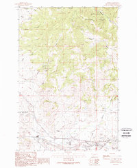
1989 Map of Ramsay
USGS Topo · Published 1989About this map
Ramsay sits at the heart of this landscape, where the industrial mining legacy of Montana meets the high country of the Deerlodge National Forest. This 1989 provisional study documents a region defined by its resource extraction and water management, visible in the concentration of adits, prospects, and the prominent Butte and Zenith Mine near Nissler. The valley floor follows Silver Bow Creek, which is flanked by the infrastructure of a working town, including a Sewage Disposal Pond and a Water Tower.
Find a feature on this map
29 named features on this map. Tap any name to fly to it.
Don’t see what you’re looking for? This feature index may not catch every label — zoom into the map to look around manually.
Map Details
Editions of this 1989 Ramsay Map
This is the sole edition of this map. No revisions or reprints were ever made.
Other maps of this area

1889 · Helena
USGS Topo · 1:250,000

1893 · Helena
USGS Topo · 1:250,000

1893 · Dillon
USGS Topo · 1:250,000

1899 · Helena
USGS Topo · 1:250,000

1903 · Helena
USGS Topo · 1:250,000

1947 · Butte
USGS Topo · 1:250,000

1955 · Dillon
USGS Topo · 1:250,000

1957 · Dillon
USGS Topo · 1:250,000

1958 · Butte
USGS Topo · 1:250,000

1958 · Dillon
USGS Topo · 1:250,000