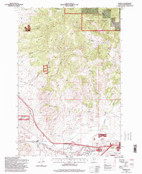
1996 Map of Ramsay
USGS Topo · Published 1998About this map
Silver Bow Creek carves a path through this high-altitude landscape, where industrial mining and national forest lands converge. The settlement of Ramsay serves as a focal point, supported by local infrastructure including a Post Office and Substation. The map reveals a history of extraction, evidenced by the Butte and Zenith Mine and numerous Prospect Adits scattered across the terrain. To the east, the community of Nissler sits near the confluence of major drainage systems and a prominent Pipeline, while heavy industry is indicated by the presence of Tailings and Sewage Disposal Ponds. The northern and eastern sections are dominated by the Deerlodge National Forest, where steep drainages like Telegraph Gulch and Meadow Gulch define the topography. This survey captures a moment when traditional resource extraction and modern communications, represented by a Communication Tower, coexist in the mountains of Silver Bow County.
Find a feature on this map
29 named features on this map. Tap any name to fly to it.
Don’t see what you’re looking for? This feature index may not catch every label — zoom into the map to look around manually.
Map Details
Editions of this 1996 Ramsay Map
This is the sole edition of this map. No revisions or reprints were ever made.
Other maps of this area

1889 · Helena
USGS Topo · 1:250,000

1893 · Helena
USGS Topo · 1:250,000

1893 · Dillon
USGS Topo · 1:250,000

1899 · Helena
USGS Topo · 1:250,000

1903 · Helena
USGS Topo · 1:250,000

1947 · Butte
USGS Topo · 1:250,000

1955 · Dillon
USGS Topo · 1:250,000

1957 · Dillon
USGS Topo · 1:250,000

1958 · Butte
USGS Topo · 1:250,000

1958 · Dillon
USGS Topo · 1:250,000