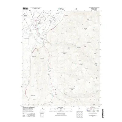
2013 Map of Ranchos De Taos
USGS Topo · Published 2013About this map
Ranchos de Taos and Talpa serve as central points in this landscape where high desert valleys meet the rising peaks of the Sangre de Cristo Mountains. The settlement pattern follows the essential water sources of the Rio Grande del Rancho and the Rio Chiquito, with historical irrigation infrastructure like the Acequia Madre del Rio Chiquito and Acequia de Avago la Loma illustrating the long-standing agricultural traditions of the region. Significant for genealogists, the map identifies several distinct burial grounds including Hart Cem, Camposanto Jesus Nazareno, and Saint Francis Cem. As the terrain climbs toward the Carson National Forest, the map records numerous named canyons and ridges such as McGaffey Ridge and Ojitos Canyon, reflecting a landscape defined by its complex topography and traditional land use.
Find a feature on this map
80 named features on this map. Tap any name to fly to it.
Don’t see what you’re looking for? This feature index may not catch every label — zoom into the map to look around manually.
Map Details
Editions of this 2013 Ranchos De Taos Map
This is the sole edition of this map. No revisions or reprints were ever made.
Other maps of this area

1954 · Raton
USGS Topo · 1:250,000

1958 · Raton
USGS Topo · 1:250,000

1964 · Los Cordovas
USGS Topo · 1:24,000

1964 · Taos
USGS Topo · 1:24,000

1964 · Tres Ritos
USGS Topo · 1:24,000

1964 · Ranchos De Taos
USGS Topo · 1:24,000

1964 · Penasco
USGS Topo · 1:24,000

1964 · Taos SW
USGS Topo · 1:24,000

1965 · Pueblo Peak
USGS Topo · 1:24,000

1965 · Shady Brook
USGS Topo · 1:24,000