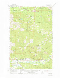
1962 Map of Randle
USGS Topo · Published 1975About this map
Randle serves as a focal point along the Cowlitz River in this 1962 survey, which documents the transition from the river valley's agricultural and residential hubs to the protected wilderness of the surrounding national forests. The map captures the infrastructure of the era, including the White Pass High Sch and the Nisqually Entrance Ranger Station at the edge of Mount Rainier National Park. To the north, the terrain rises into the Snoqualmie National Forest, while the south is dominated by the Gifford Pinchot National Forest. Geologists and historians can trace the rugged topography of the Sawtooth Ridge and identify numerous high-elevation water bodies like Bertha May Lake and Cora Lake. The presence of several campgrounds, such as Longmire Campground and Maple Leaf Campground, reflects the region's long-standing role as a gateway for Pacific Northwest recreation.
Find a feature on this map
78 named features on this map. Tap any name to fly to it.
Don’t see what you’re looking for? This feature index may not catch every label — zoom into the map to look around manually.
Map Details
Editions of this 1962 Randle Map
2 editions found

Other maps of this area

1919 · Mount St Helens
USGS Topo · 1:125,000

1924 · Mt Rainier
USGS Topo · 1:96,000

1926 · Steamboat Mtn
USGS Topo · 1:125,000

1928 · Mt Rainier
USGS Topo · 1:125,000

1931 · Steamboat Mtn
USGS Topo · 1:125,000

1937 · Eatonville
USGS Topo · 1:125,000

1950 · Yakima
USGS Topo · 1:250,000

1953 · Hoquiam
USGS Topo · 1:250,000

1956 · Mineral
USGS Topo · 1:62,500

1956 · Kapowsin
USGS Topo · 1:62,500