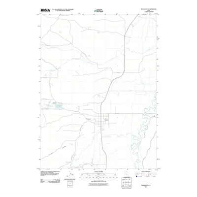
2011 Map of Randolph
USGS Topo · Published 2011About this map
Randolph serves as the central hub of this eastern Utah landscape, where the town's grid meets the wandering path of the Bear River. This 2011 survey captures the area's agricultural and natural character, defined by an intricate network of irrigation and water sources like Little Creek Reservoir and numerous named springs, including Jacobsen Springs and Brough Spring. The Bear River meanders heavily through the eastern flats, creating a complex series of oxbows and wetlands that contrast with the more structured road network of Big Creek Rd and Otter Creek Rd. Genealogists and local historians will find value in the clear location of the Randolph City Cemetery and outlying landmarks like Rex Ranch. The presence of the Little Creek Campground and the terrain of Dry Canyon to the southwest illustrate the region's balance between managed ranching land and open wilderness.
Find a feature on this map
37 named features on this map. Tap any name to fly to it.
Don’t see what you’re looking for? This feature index may not catch every label — zoom into the map to look around manually.
Map Details
Editions of this 2011 Randolph Map
This is the sole edition of this map. No revisions or reprints were ever made.
Other maps of this area

1912 · Randolph
USGS Topo · 1:125,000

1954 · Ogden
USGS Topo · 1:250,000

1958 · Ogden
USGS Topo · 1:250,000

1960 · Ogden
USGS Topo · 1:250,000

1968 · Rex Peak
USGS Topo · 1:24,000

1968 · Randolph
USGS Topo · 1:24,000

1968 · Woodruff
USGS Topo · 1:24,000
1968 · Woodruff Narrows
USGS Topo · 1:24,000
1969 · Leefe
USGS Topo · 1:24,000
1969 · Birch Creek Reservoirs
USGS Topo · 1:24,000